- June 7, 2020
- Posted by: Mukul Bhatia
- Category: Featured, INTERNATIONAL AFFAIRS, Latest Work, OPINION
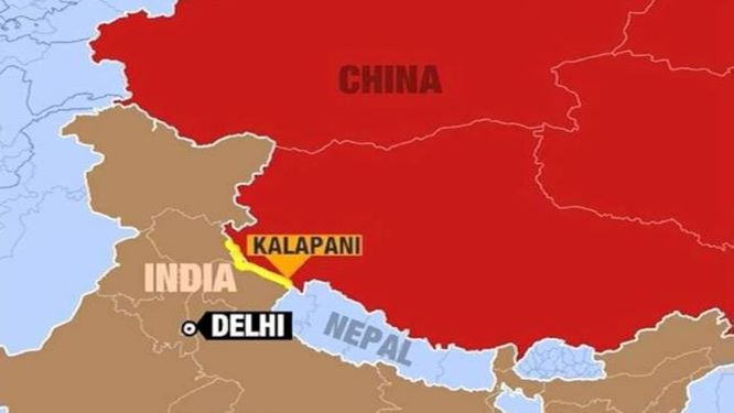
The ongoing dispute between India and Nepal over the Kalapani-Limpiadhura-Lipulekh trijunction can perhaps be best explained within the discourse of ‘cartographic anxiety’. Coined by Sankaran Krishna, cartographic anxiety emanates from the process of territorial consolidation pursued by a political community in order to model itself on the standard established by the European nation-state. In this sense, cartographic anxiety becomes a definitive marker of postcoloniality, for this process has always been implicit in the transition of former colonies to modern nation-states (Krishna, 1994). And while credulous voices have hailed India’s ascent to a power in its own right, renouncing the use of typifications such as ‘Post-colonialism’ to describe its body politic, incidents such as the recent escalation in tension between India and Nepal beg a more subtle inquiry, especially in the realm of policy.
The issue received traction with India’s inauguration of the Darchula-Lipulekh pass link road that cut across the Kalapani area during May 2019 and then again in November 2019 with the publication of a revised political map which included the same area as a part of its Pithoragarh district in Uttarakhand. What has followed is a response ranging from protests to a political outcry in Nepal against India’s unilateralism that cut across party lines. Developments such as deployment of the Nepalese Armed Police Force at the border point of Lipulekh attempts by the Nepal Government to write its claim over the disputed area into the Constitution through a counter-revision of the country’s map stand to remind us of the violence rooted in territoriality.
It might be tempting to emphasize the immediate context of this dispute. These developments came as fissures within Nepalese PM KP Oli’s Communist Party resulted in internal challenges to his office. Oli’s adoption of a hard-lined approach against India, then, can be viewed as an attempt to regain legitimacy. Of course, resentment attributed to a general feeling of being ‘pushed around’ by the Indian state only intensified Nepalese nationalism. On the Indian side too, the opening of the link road that provides Indian pilgrims easy access to Kailash Mansarovar has obvious domestic political currency for the ruling Bhartiya Janta Party. The experience of defeat during the Sino-Indian war of 1962, that has led to a continued presence of Indian troops in the Kalapani area, has also revealed the area’s strategic importance to New Delhi. Thus, these factors form the immediate context of this dispute. However, it is important to be cognizant of the broader narrative in which these developments have occurred. The manner in which interests are articulated and claims are substantiated matters and can lend a necessary ethical dimension to policy.
It is indeed interesting to note how both India and Nepal have invoked colonial cartography to substantiate their respective claims over the territory. To begin with, a recurring facet of colonial legacy is the Treaty of Sugauli signed between the East India Company and Nepal that ended the Anglo-Nepalese war. The Kali river denoted the western border between British India and Nepal, requiring Nepal to renouncing any claim west of the river. The present dispute thus arises from the competing claims over the identification and the source of the river Kali. The Nepalese administration cites the maps prepared by the Survey of India between 1816 to 1856 that established Limpiyadhura as the source of the river Kali. However, Manandhar and Koirala of the Tribhuvan University noted how subsequent maps produced by the British administration manipulated the boundaries established by the treaty of 1816. They asserted that the shifting of the international boundary from river Kali to Lipu Khola towards the east, and then later with the 1879 map shifting it even further beyond Lipu Khola was ‘unauthorised, unilateral and without any agreement of the Government of Nepal’ (Manandhar & Koirala, 2001). The maps produced between 1879 and 1928/29 came to be used by Independent India to defend its claims over the territory (Gupta, 2000). Institutional measures such as Nepal-India Joint Technical Level Boundary Committee have also largely failed to resolve the status of Kalapani.
Of course, the maps represent the expansionist motives of the Empire, however, both India and Nepal needed prevailing representations of their own landscapes in order to justify their own existence as well-defined nation-states. The fact that the Kali river has changed course over the decades, further exacerbating the problem, is an example of how these cartographic exercises are removed from ‘lived geographies’. Thus, it was not due to the absence of alternate representations of the territory that colonial cartography was resorted to but was instead an important aspect of the nation-state project. Consider this excerpt from a letter sent by Sardar Vallabhai Patel to Jawaharlal Nehru in 1950:-
“Nepal has a weak oligarchic regime based almost entirely on force: it is in conflict with a turbulent element of the population as well as with enlightened ideas of the modern age. In these circumstances, to make people alive to the new danger or to make them defensively strong is a very difficult task indeed and that difficulty can be got over only by enlightened firmness, strength and a clear line of policy.” (Quoted in Singh, 2010)
This excerpt clearly represents an ideational continuity from British Administered India to Independent India, that sought to view Nepal from the lens of the coloniser. The Nepalese demands to settle the status of the region began to take a definite shape only during the 1990s as political processes in Nepal increasingly began to take ‘modern’ form.
Thus, cartographic anxiety is what has taken over both New Delhi and Kathmandu, with the former seeking to increase its strategic advantage and the latter trying to assert itself in the face of hegemonic challenges in trying to protect its status as a sovereign. Postcoloniality in this context should therefore provide policy makers a roadmap to settle further disputes.
It is imperative for the policy establishment in India to find newer vocabularies to deal with Nepal. Remarks such as those by late Minister of External Affairs Sushma Swaraj in 2016 that called for India to be considered as an ‘elder brother’ instead of ‘big brother’, although relevant in its particular context of detaching India from the negative connotations attached to ‘big brother’, should be replaced with a vocabulary that affirms Nepal’s equal status in their bilateral relations. In his seminal work, Pax Indica, Shashi Tharoor, while critiquing India’s dealings with Nepal, asserts that policymakers in India need to take sufficient note of the ‘Nepalese pride’ (Tharoor,
It is also important for New Delhi to recognise that the revised political map that defined Kalapani region as an Indian territory, was attached to the larger cause of representing Ladakh and Jammu and Kashmir as Union Territories, a move that has elicited domestic criticism as well. From this frame of reference, remarks such as the one made by Army Chief General M M Naravane that called out on Nepal for raising protests against the Lipulekh Link road ‘at the behest of someone else’, are bound to face diplomatic backlash. Additionally, the policymakers on both sides should not fall prey to ad-hocism, and must use this opportunity that clearly highlights the colonial aspect of their conundrum to revise a plurality of aspects of the Indo-Nepalese relations. A nuanced approach, that emphasizes India’s recognition of Nepal as a sovereign equal in status on the one hand and privileges Nepal in its dealings with India owing to a consciousness of the disadvantages that ‘India-locked’ Nepal faces, should take precedence. Previous measures such as Bilateral Treaty on Peace and Friendship in 1950, should also be included in the policy discourse. It is not only within the realm of border management that India’s engagement with Nepal has been termed ‘imperialistic’. Multiple academic as well as political voices in Nepal and beyond have often highlighted the unequal terms of the 1950 Treaty (Thapliyal, 2012). Stuck between the commitments mandated by the treaty and the commitments made to its own people, Nepal has often found itself imposing measures that went against the spirit of the treaty. Thus, it is essential that the privileged status of Nepal with respect to India is written into any subsequent measures adopted to improve bilateral relations. Of course, like most measures adopted in the past, such measures too shall be influenced by prevalent power configurations and political interests of the actors involved. However, taking note of postcoloniality would mean building an institutional mechanism that allows a continuous revision and renegotiation of the nations’ relative positions. This is where India and Nepal might benefit from their history of cooperation in a variety of areas.
Finally, the exclusionary aspects of varied representations of the region need to be taken note of by the policymaker on both sides. Considering the case of the villages surrounding this strategically important region is an important aspect of a comprehensive solution, an aspect that is often lost with abstract articulations of interest and strategy. Now doubt, the Lipulekh link road brings prospects for greater connectivity among villages such as Garbyang which have historically struggled to procure basic necessities. A deliberate effort to understand how any agreement in the future with respect to the region as well as dealings in the past influence the lived realities of the inhabitants. Measures such as an on-ground comprehensive socio-political, cultural, and economic study of the region with representations from both sides could go a long way in determining its future and consequently, the future of Indo-Nepalese relations.
References:
1) Gupta A. K. (2000). Kalapani: A Bone of Contention Between India and Nepal. Institute of Peace and Conflict Studies. Retreived June 4, 2020, from http://www.ipcs.org/comm_select.php?articleNo=422
2) Krishna, S. (1994). Cartographic Anxiety: Mapping the Body Politic in India. Alternatives: Global, Local, Political, 19(4), 507-521. Retrieved June 4, 2020, from www.jstor.org/stable/40644820
3) Manandhar, M., & Koirala, H. (2001). Nepal-India Boundary Issue: River Kali as International Boundary. Tribhuvan University Journal, 23(1), 1-21. https://doi.org/10.3126/tuj.v23i1.4550
4) Singh, R. (2010). The Unmaking of Nepal. Centre for Land Warfare Studies.
5) Thapliyal, S. (2012). India and Nepal Treaty of 1950: The Continuing Discourse. India Quarterly, 68(2), 119-133. Retrieved June 4, 2020, from www.jstor.org/stable/45072541
6)Tharoor, S. (2013). Pax Indica: India and the World of the Twenty-first Century. Penguin Random House India Private Limited.
The views expressed in this paper are the views of the authors and do not necessarily reflect the views or policies of PCI, its Board of Directors, or the governments they represent.